Trail On foot La Morte - Alpe de grand serre Taillefer Lac Fourchu Bivouac - Photo

Alpe de grand serre Taillefer Lac Fourchu Bivouac

 yann07
yann07

User

© OpenStreetMap contributors
Length
Length
26 km
Max alt
Max alt
2851 m
Uphill gradient
Uphill gradient
1783 m
Km-Effort
Km-Effort  
50 km
Min alt
Min alt
1352 m
Downhill gradient
Downhill gradient
1782 m
Boucle
Boucle
Yes
Creation date :
2021-08-19 18:56:36.917
Updated on :
2021-08-19 19:04:49.57

(0 Reviews)

On foot
On foot
11h15
Difficulty : Very difficult

Scan this QR Code to open this trail in the SityTrail application

FREE GPS app for hiking

Logo SityTrail SityTrail

IGN / Geographical institutes

Download SityTrail from the App Store Download SityTrail from Google Play

Logo SityTrail SityTrail World

The world is yours!

Download SityTrail from the App Store Download SityTrail from Google Play Download SityTrail on Huawei AppGallery

About

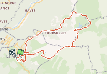
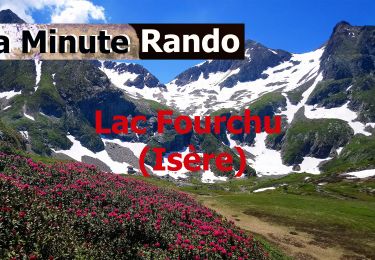
Trail On foot of 26 km to be discovered at Auvergne-Rhône-Alpes, Isère, La Morte. This trail is proposed by yann07.

Description

Randonnée en deux jours avec un Bivouac au lac Fourchu.
La descente du Taillefer par le sentier Nord en direction du plateau du lac est tres long et glissant avec deux passages ou il faut mettre les mains
Alpe du grand serre au lac fourchu par le Taillefer envron 7 Heures sans les poses.
Le deuxieme jour environ 4H30 sans les poses

Elevation profile

Photos

Positioning

Country:
France
Region :
Auvergne-Rhône-Alpes
Department/Province :
Isère
Municipality :
La Morte
Location:
Unknown
Start:(UTM)
724990 ; 4990165 (31T) N.

Trails nearby

Trail Snowshoes La Morte - Belvedere et Balcon de La Romanche - Photo
Snowshoes
patjobou

Snowshoes

Medium
(1)
La Morte, Auvergne-Rhône-Alpes, Isère, France
10.3 km | 16.8 km-effort
4h 18min
Yes
Trail Walking Livet-et-Gavet - lac fourchu 2018 - Photo
Walking
goizet

Walking

Medium
(1)
Livet-et-Gavet, Auvergne-Rhône-Alpes, Isère, France
10.1 km | 16.5 km-effort
6h 58min
Yes
Trail Walking Lavaldens - Plancol - Photo
Walking
patjobou

Walking

Medium
Lavaldens, Auvergne-Rhône-Alpes, Isère, France
10.6 km | 19.3 km-effort
5h 6min
Yes
Trail Walking Séchilienne - Col De La Madeleine en circuit par les Pavies de Sėchilienne - Photo
Walking
Emelle

Walking

Medium
(1)
Séchilienne, Auvergne-Rhône-Alpes, Isère, France
12.1 km | 24 km-effort
5h 44min
Yes
Trail On foot Livet-et-Gavet - Lac Fourchu (14 juillet 2020) - Photo
On foot
crocau

On foot

Easy
Livet-et-Gavet, Auvergne-Rhône-Alpes, Isère, France
8.1 km | 13.9 km-effort
3h 9min
Yes
Trail Walking Livet-et-Gavet - Plateau des lacs au pied du Taillefer - Photo
Walking
GuyVachet

Walking

Medium
Livet-et-Gavet, Auvergne-Rhône-Alpes, Isère, France
11.9 km | 19.1 km-effort
6h 16min
Yes
Trail Walking Livet-et-Gavet - Lac fourchu 2 - valette - Description et vidéo - Photo
Walking
bob2023

Walking

Medium
Livet-et-Gavet, Auvergne-Rhône-Alpes, Isère, France
11.9 km | 19 km-effort
3h 56min
Yes
Trail Walking Livet-et-Gavet - Lac Fourchu via lac canard - Photo
Walking
lviallet

Walking

Very easy
(1)
Livet-et-Gavet, Auvergne-Rhône-Alpes, Isère, France
8.6 km | 14.4 km-effort
3h 2min
Yes
Trail Walking Livet-et-Gavet - Untitled - Photo
Walking
ascq

Walking

Medium
(2)
Livet-et-Gavet, Auvergne-Rhône-Alpes, Isère, France
18.1 km | 32 km-effort
6h 22min
Yes


Close
My subscriptions